

(NEW YORK) — Tropical Depression Four is expected to strengthen into Tropical Storm Debby later on Saturday – and could reach near hurricane strength as it heads north over the weekend.
Hurricane Watches and Tropical Storm Warnings are in effect for the west coast of Florida as this system makes its way into the region this weekend.
On Saturday morning, Tropical Depression Four was over Cuba, with winds of 35 mph. The storm is forecast to enter the Gulf of Mexico off the southwest coast of Florida Saturday afternoon and is forecast to make landfall late Sunday night or early Monday morning along Florida’s Big Bend region.
A Hurricane Watch has been issued from the Aucilla River to Yankeetown, Florida. Tropical Storm Watches and Warnings are in effect for much of the west coast of Florida, with more alerts expected to be issued as this storm gets closer.
Strengthening is expected as the storm feeds off the warm water in the Gulf of Mexico, where water temperatures are averaging around 85 degrees.
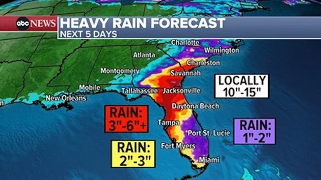
The main impact from this storm will be flooding due to rainfall. While the highest rain totals will be dependent on the storm’s path, much of Florida will be getting drenched from this system.
Widespread rain totals of 2 to 5 inches are likely in northern Florida, with localized areas possibly seeing 5 to 15 inches of rainfall over the next four days.
Storm surge may also be an issue, with 2 to 4 feet of potential surge from Bonita Beach to the Suwannee River area. Up to 3 to 5 feet of surge is in the forecast from the Chassahowitzka to Aucilla River.
Damaging winds are possible as well, and will be dependent on the strength of this storm at landfall.
Tropical storm-force winds are likely, ranging between 39 to 73 mph, in central and northern Florida. Hurricane-force winds are possible in the Big Bend region on Sunday night into Monday morning.
As of now, the National Hurricane Center forecasts that the storm will make its way into the Big Bend region of Florida as a strong tropical storm late Sunday night or early Monday morning.
The storm then passes across northern Florida and is expected to reemerge on the Atlantic side. While its track remains questionable thereafter, some projections keep it drifting off the coast of Georgia and the Carolinas long enough to drench coastal areas with several more inches of rain.
Copyright © 2024, ABC Audio. All rights reserved.