(NEW YORK) — The time of year that typically sees the most tropical systems forming in the Atlantic Basin is almost here.
The past three weeks in the Atlantic Basin have been notably quiet with no named storm formations since Ernesto on Aug. 12.
The last time the Atlantic had no named storm formations between Aug. 13 and Sept. 3 was in 1968, Philip Klotzbach, senior research scientist at Colorado State University, told ABC News. There has not been a named storm anywhere in the Atlantic Basin for more than two weeks.
The peak of the Atlantic hurricane season is Sept. 10, according to the National Hurricane Center. Historically speaking, about two-thirds of all storm activity occurs between Aug. 20 and Oct. 10.
Earlier this year, the National Oceanic and Atmospheric Administration predicted a very active Atlantic hurricane season for 2024.
One of the explanations for the lack of storm systems forming in the Atlantic Basin in recent weeks is due to the Saharan Dust moving across the Atlantic Ocean, scientists say. Large Saharan dust outbreaks brought widespread, intense plumes of dust and lots of dry air across the tropical Atlantic during July and much of August, Ed Nowottnick, an atmospheric scientist at NASA’s Goddard Space Flight Center, told ABC News.
Tropical waves have been exiting the African continent so far north that they have been pulling in lots of dust and dry air, limiting their chances for development, according to researchers and tropical weather experts at Colorado State University.
While the frequency of these dust plumes has been around average, they have been more intense and widespread in nature, Nowottnick said.
The timing and location of any dust plumes and large areas of dry air play a big role in tropical development, Nowottnick said. Dust levels are trending down, closer to average for this time of the year, which should begin to minimize its role as an inhibiting factor in the coming weeks.
Unfavorable conditions in the upper atmosphere and a northward displaced storm track across West Africa are also playing a role, experts said.
The northward displaced storm track across West Africa has brought abnormal rainfall to portions of Africa outside the typical setup amid the monsoon season, Dan Harnos, a meteorologist at NOAA’s Climate Prediction Center, told ABC News.
Disturbances crossing this region are then entering the Atlantic over relatively cooler waters and with greater exposure to dry air from the mid-latitudes, which hinder the chances of a storm developing.
What to expect for the rest of the Atlantic hurricane season
Below-average activity remains likely over the next two weeks, according to tropical weather experts at Colorado State University. However, the seasonal forecast remains on track to be above average in the end, after a couple more weeks of usually quiet conditions, they said.
Towards the middle of the month, large-scale environmental conditions look to become more favorable for tropical cyclone activity in the Atlantic Basin.
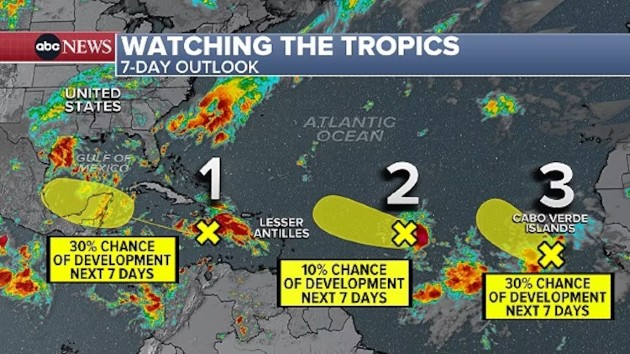
Three tropical disturbances are currently being monitored for potential development in the Atlantic Basin. But the latest update from the National Hurricane Center indicates that they all have a low chance of development over the next seven days.
There are still no major concerns or threats at this time.
A tropical disturbance moving westward across the Caribbean Sea has a 30% chance of development in the next seven days and a 0% chance in the next two days, forecasts show. This system will bring heavy rain and gusty winds to Nicaragua and Honduras this weekend and then to the Yucatan Peninsula of Mexico early next week.
Another tropical disturbance, located off the coast of Africa, has a 20% chance of development in the next week.
A third tropical disturbance has just a 10% of development over the next week as it sweeps across the central Atlantic Ocean.
At this point, it looks like the U.S. is in the clear for the foreseeable future.
Looking ahead to mid-September, NOAA’s Climate Prediction Center’s long-range Global Tropical Hazards Outlook calls for a slight to moderate chance of new tropical development over the Central Atlantic Ocean.
While this isn’t a strong signal for activity ramping up, it highlights that changes are likely coming in a few weeks that support more activity.
NOAA’s hurricane outlook for the 2024 season calls for 17 to 24 named storms, with eight to 13 of them becoming hurricanes, and four to seven of those reaching major hurricane strength. So far, there have been five named storms in the 2024 season, with three hurricanes.
The history of peak hurricane season
The top two busiest Atlantic hurricane seasons on record are 2020 and 2005, respectively, records show. Both years had around half the total number of named storms for the season occurring after Sept. 3.
By Sept. 3, 2020, there had already been 15 named storms, up to the letter “O,” with 15 more named storms to follow through the end of the season, on Nov. 30.
In 2005, there had already been 13 named storms by Sept. 3, up to the letter “M,” with 14 more named storms to follow that year.
The average number of named storms in the Atlantic Basin during one season is 14, with seven hurricanes on average.
Numerous factors play an important role in tropical cyclone activity and a seasonal outlook. This year, the end of El Niño giving way to a developing La Niña event in the equatorial eastern Pacific, near-record warm ocean temperatures across much of the Atlantic Basin, and above-average African monsoon activity were all primary reasons for this forecast.
Copyright © 2024, ABC Audio. All rights reserved.


