(NEW YORK) — Tropical Storm Francine was forecast to strengthen into a hurricane early Tuesday ahead of its expected landfall in Louisiana on Wednesday, the National Hurricane Center said.
The storm’s winds remained at about 65 mph just after midnight, the center said in its 1 a.m. CT update on Tuesday.
“Francine will likely become a hurricane today, with significant strengthening expected before it reaches the coast,” the update said.
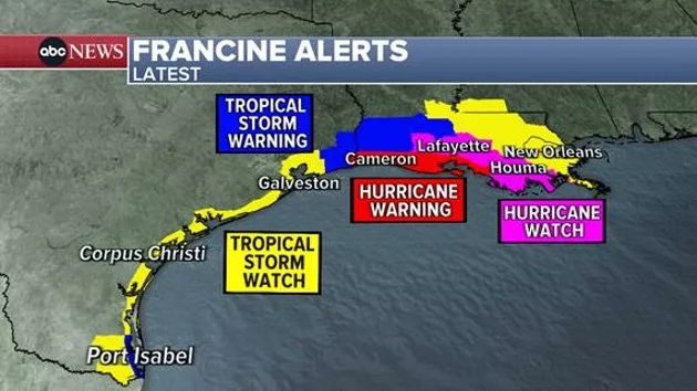
Weather officials issued a series of hurricane warnings and watches for coastal areas as the storm has churned in the Gulf of Mexico. Strong winds are extending about 140 miles outward from the storm.
Francine is expected to make landfall Wednesday afternoon in southwestern Louisiana as a Category 2 storm with 100 mph winds.
A Storm Surge Warning was in effect for High Island, Texas, to the mouth of the Mississippi River and Vermilion Bay in Louisiana. A Hurricane Warning was in effect for the Louisiana coast from Sabine Pass eastward to Morgan City, officials said.
The storm is expected to bring rain to much of the coast from northeastern Mexico through Texas, Louisiana and Mississippi. Most areas in the storm’s path will see between 4 inches and 8 inches of rain, with a few areas getting as much as 12 inches.
“This rainfall could lead to considerable flash and urban flooding,” weather officials said.
Copyright © 2024, ABC Audio. All rights reserved.


