More than 110 million Americans are under alerts Sunday for flooding, mudslides and strong winds as dangerous winter weather left tens of thousands without power throughout the South and caused multiple deaths in Kentucky.
Heavy rain continued to produce serious flooding across parts of the Southern United States on Sunday morning, where rapidly rising floodwaters inundated roadways and spurred some evacuations. Meanwhile, snow and sleet made for messy weather in the Northeast and mid-Atlantic.
Throughout Saturday and into Sunday, there were numerous flash flood warnings issued across parts of Kentucky, Tennessee, West Virginia and North Carolina.
The impact from flooding in his state is “massive,” Kentucky Gov. Andy Beshear said Sunday in a statement on X, and there have been hundreds of water rescues and multiple fatalities.
“Evacuations are continuing as this event will continue through today,” Beshear said. “Please be careful if you have to travel.”
More than 300,000 customers spread across Kentucky, Alabama, Mississippi and Virginia were without power Sunday morning, according to Poweroutage.us.
In advance of the heavy rainfall and widespread flooding, Beshear issued a state of emergency, saying Saturday that the entire state would be under significant threat through at least Sunday morning.
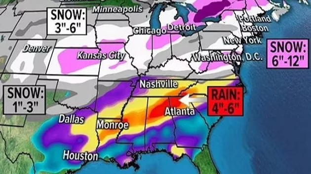
Parts of western Kentucky and northwestern Tennessee reported receiving 4 to 7 inches of rain Saturday night into Sunday. The area around Clarksville, Tennessee, northwest of Nashville, reported getting around 7.6 inches of rain.
Beshear also said he wrote to President Donald Trump “requesting an emergency disaster declaration for Kentucky due to the severe weather and impacts across our state,” which would release federal funds to aid the response.
The governor said he had also spoken to Homeland Security Secretary Kristi Noem and the acting director of FEMA.
Serious flooding around Panbowl Lake in Jackson — about 85 miles southeast of Lexington — led to the evacuation of a nursing home and a hospital as precautions.
The Louisville Metro Police Department said its river patrol and diving teams were working with local fire departments to conduct water rescues “throughout the city,” with almost 30 such rescues completed and more expected. Authorities in Simpson County, Kentucky, also reported water rescues.
Areas along the border between Kentucky and Tennessee reported the highest reported rain totals, with between 4 and 7 inches of rain.
In Tennessee, more than 50 residents of a nursing home in Macon County, about 65 miles northeast of Nashville, were evacuated to higher ground after rising water began to approach, according to the Macon County Emergency Medical Services.
Joe Pitts, the mayor of Clarksville, Tennessee, said in a statement that close to 4 inches of rain caused “alarming scenes of flash flooding” in the area. Up to 2 more inches of rain is expected through the day and into Sunday evening, Pitts said.
The National Weather Service extended a flash flood emergency for several counties in West Virginia and in southwestern Virginia until 8 a.m. Sunday, calling the flash flooding an “extremely dangerous and life-threatening situation.”
In the town of Richlands, in southwestern Virginia’s Tazewell County, residents of many areas were encouraged to evacuate, according to the local police department.
“Multiple areas of the town are currently experiencing flooding, with the river expected to rise even higher,” the police department said in a Facebook post on Saturday afternoon. “Residents in previously flooded areas are strongly advised to evacuate at once. Evacuation should not be postponed.”
Virginia Lt. Gov. Winsome Earle-Sears said National Air guardsmen and soldiers had been deployed to help the response. “Don’t try to outrun a flood or anything,” she wrote in a Facebook post. “Get the higher ground if you need to.”
In West Virginia, Gov. Patrick Morrisey declared a state of emergency in 10 counties. Evacuations were underway in southern West Virginia, with the Blue Stone River experiencing major flooding near Spanishburg.
In areas affected by heavy rain, landslides and rockslides are possible.
Storms with damaging winds and flash flooding were the main threats, but there was also the possibility of tornadoes.
Residents were urged to pay attention to severe weather warnings overnight, as the tornado risk continued into Sunday morning for parts of Georgia. Warnings could be extended east to the Atlantic coastline as the storms progress.
Snow and ice in the Northeast
Meanwhile, snow moved into portions of the Northeast and mid-Atlantic on Saturday afternoon, and conditions were expected to deteriorate.
The snow is expected to change to sleet and rain as this system moves through the Northeast into Sunday.
The switch from snow to sleet and rain will create slushy conditions and hazardous travel.
Snow totals could be topping a foot across parts of central and northern New England and northern New York state. For cities like Hartford and Boston, a slushy 3 to 6 inches is likely before rain falls and compacts the snow.
86 million under wind alerts
High wind alerts are in effect for more than 86 million people across 22 states for Sunday and Monday.
Gusts of up to 60 mph are possible in the Northeast and mid-Atlantic through Sunday night, while gusts of up to 45 mph are possible in the Southeast.
A severe thunderstorm warning was issued for Atlanta at 4:30 a.m. on Sunday. Wind gusts at the city’s Mercedes Benz Stadium were recorded up to 71 mph.
More than 215,000 customers were without power in Georgia as of the early hours of Sunday morning.
ABC News’ Victoria Arancio and Josh Richardson contributed to this report.
Copyright © 2025, ABC Audio. All rights reserved.