(NEW YORK) — Even though Beryl lost its status as a tropical storm, it still packed a punch as it moved from Arkansas to Michigan, bringing with it tornadoes and flash flooding.
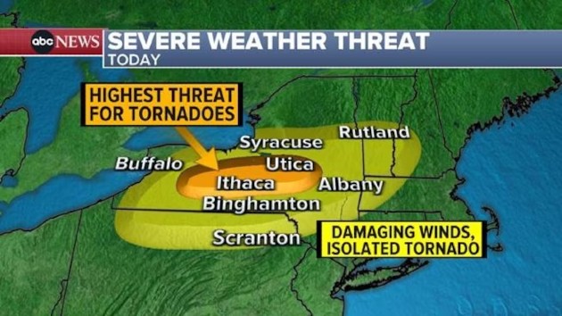
The remnants of the storm, which had made landfall in Texas on Monday as a Category 1 hurricane, are expected to move on Wednesday afternoon and evening into western Pennsylvania, upstate New York and northern New England, where tornadoes are possible.
In addition to tornadoes, there is a significant threat for flash flooding from northern New York into Vermont and New Hampshire, with up to 5 inches of rain is possible in a short period of time.
The worst of Beryl should stay just north and west of Interstate 95 corridor.
At least eight people were killed when Hurricane Beryl tore through Texas and Louisiana on Monday, including a civilian employee of the Houston Police Department who drove into flood conditions on the way to work, officials said.
Multiple fatalities were due to fallen trees, officials said.
Two reported tornadoes had ripped through Kentucky and Indiana on Tuesday.
Up to 8 inches of rain fell just out of Little Rock, Arkansas, flooding homes and neighborhoods on Tuesday. And Up to 3.6 inches of rain fell in about 1 hour and 40 minutes in Lansing, Michigan, producing flash flooding.
More than 1.7 million power customers were without power in Texas early on Wednesday, almost two days after the storm rolled through the state, according to PowerOutage.us, a website that tracks power providers.
Copyright © 2024, ABC Audio. All rights reserved.


